Global Aerial Imaging Market Size and Growth By Type (Unmanned Aerial Vehicles Helicopters, Fixed-Wing Aircraft, Others), Application (Government Agencies Military and Defense, Energy Sector, Agriculture and Forestry, Civil Engineering, Commercial Enterprises, Others) - Industry Outlook 2020 to 2035
January 2026
Aerospace and Defence
Pages: 130
ID: MRS2010
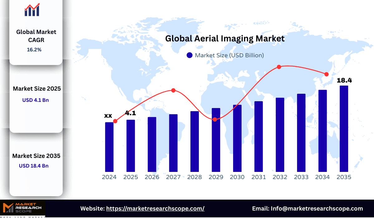
Global Aerial Imaging Market Projected to Grow At A CAGR of 16.2% During Forecast Period
Aerial Imaging Market Key Highlights
- In 2025, the aerial imaging Market size was valued at US$4.1 billion
- The market is expected to reach US$ 18.4 billion by 2035
- The market is anticipated to grow at a CAGR of 16.2% during the forecast period.
- Based on type, the unmanned aerial vehicles segment held the largest revenue share of the market in 2025
- Based on application, the government agencies segment held the largest revenue share of the market in 2025
- In terms of region, North America is expected to witness the highest growth over the forecast period.
- Asia-Pacific is the fastest-growing region
Global Aerial Imaging Market Overview
The global aerial imaging market size is predicted to grow from US$ 4.1 billion in 2025 to US$ 18.4 billion in 2035; it is expected to grow at a CAGR of 16.2% from 2025 to 2035.
With the assistance of sensors, aerial photography offers photographs of ground surfaces taken from an elevated location. The photos are captured using cameras mounted on various aircraft, including helicopters, airships, kites, balloons, and unmanned aerial vehicles (UAVs). Among numerous verticals, such as civil engineering, science, government, agriculture, and others, aerial imaging finds wide application. Satellite imagery as a replacement alternative, however, is expected to limit the growth of the aerial imaging industry. For the aerial imaging industry, new technologies like GIS (geographic information system), LiDAR systems, and 360-degree vision cameras are expected to create substantial opportunities. Growing application areas are expected to provide the aerial imaging industry with avenues of expansion. The technology offers an effective solution for numerous purposes, such as route construction, planning, renovation of volume estimation maps, etc. For different purposes, aerial photography is used, such as construction & development, geospatial technology, disaster management, research & conservation, etc. Over the projected period, rising technical advances in camera systems and aerial platforms are expected to fuel market growth. Furthermore, it is also expected that growing awareness of the advantages of this technology would further promote consumer demand. Over the forecast era, increasing location-based services are expected to drive aerial imaging market development.
Aerial photography sees applications (insurance, real estate, and tourism) through numerous industries, including government, energy, defense, agriculture & forestry, civil engineering & archaeology, media & entertainment, and others. With the assistance of spatial data captured from orthographic photographs, aerial photography offers data such as ground cover maps, landscape maps, soil maps, and geology maps. A leading source of aerial imagery and geospatial data has always been the security and protection market. Due to the high degree of recognition among customers and the availability of high-resolution aerial imagery from various vendors, the use of aerial imagery in this field has now increased considerably. Construction and growth, geospatial technology, and the management of natural resources are likely to appear as exciting aerial imaging applications over the next few years.
This report provide an overview of the global aerial imaging industry, including market size, historic market revenue, sales data, value chain analysis, market segmentation by type, by application, by region, key growth drivers and its competitive landscape. Also, it analyzes the segments data by type and by application, sales, revenue, and price, from 2020 to 2035. Evaluation and forecast the market size for aerial imaging sales, projected growth trends, production technology, application and end-user industry. Within the type segment, unmanned aerial vehicles (UAVs) is the fastest growing sub-segment and is expected to grow at a CAGR of % and in the application section, government agencies is the fastest growing segment.
This report forecasts revenue growth at global, regional, and country levels and provides an analysis of the latest industry trends in each of the sub-segments from 2020 to 2035.
Aerial Imaging Market Segmentation
By Type:
Type-wise reakup of the global aerial imaging market
Unmanned Aerial Vehicles Helicopters
Fixed-Wing Aircraft
Others
Based on their type, aerial imaging are further classified as, unmanned aerial vehicles, helicopters, fixed-wing aircraft, others, unmanned aerial vehicles (UAVs) type segment dominated the market and accounted for a share of % in 2025. This dominance is mainly driven by due to their flexibility in operations, cost-effectiveness, and their capacity to provide high-resolution images with little logistical hassle. Compared to helicopters, fixed-wing aircraft, and UAVs offer a more scalable and economical solution, which has accelerated their adoption across both public and private sectors. It also widespread adoption across varied industries such as agriculture, construction, and defence industries is driven by efficiency and cost-effectiveness.
By Application:
Application-wise breakup of the global aerial imaging market
Government Agencies Military and Defense
Energy Sector
Agriculture and Forestry
Civil Engineering
Commercial Enterprises
Others
Based on application, global aerial imaging market Aerial imaging by application can be used in varied industries such as government agencies, military and defense, energy sector, agriculture and forestry, civil engineering, commercial enterprises, others. Government agencies accounted for the largest market revenue share in 2025. This growth is driven by due to growing demand for advanced aerial imaging solutions in defense, law enforcement, and disaster management
Aerial Imaging Market: Geographic Analysis
Because of the production of UAVs and PAMS, North America is projected to be the key regional market over the next six years. In addition, it is also projected that the European aerial imaging market will expand at a significant pace over the forecast period. Due to high security and military investments in countries like India, China, etc., Asia-Pacific is estimated to expand significantly. The European aerial imaging industry placed second in 2019 and is predicted to stay in this position in the near future. The increasing use of aerial imaging for aquatic landscape surveillance, the growing evolution of imaging Intelligence solutions and the growing number of aerial photography collection organizations in Europe are stimulating this regional industry. The major regions covered in this research are as follows:
BlomNorth America
Asia-Pacific
Europe
South America
Middle East and Africa
Competitive Landscape
The global market is highly fragmented with the presence of large number of players globally. Some of the major companies include, Blom ASA, Digital Aerial Solutions, Cooper Aerial Surveys, Fugro, Landiscor Aerial Information, EagleView Technology, Nearmap, Kucera International, Quantum Spatial
Company Profiles:
Major companies operating in the aerial imaging market:
Blom ASA
Digital Aerial Solutions
Cooper Aerial Surveys
Fugro
Landiscor Aerial Information
EagleView Technology
Nearmap
Kucera International
Quantum Spatial
Aerial Imaging Market Scope:
| Report Attribute | Details |
| Report Objective | To provide comprehensive insights into the aerial imaging market size, trends, segmentation, regional dynamics, and competitive landscape. |
| Base Year | 2025 |
| Historical Period | 2020–2024 |
| Forecast Period | 2025–2033 |
| Market Size In 2025 | US$4.1 billion |
| Market Size In 2035 | UD$18.4 billion |
| Growth Rate | 16.2% |
| Segments |
By Product Type
Unmanned Aerial Vehicles Helicopters, Fixed-Wing Aircraft, Others
By Application
Government Agencies Military and Defense, Energy Sector, Agriculture and Forestry, Civil Engineering, Commercial Enterprises, Others |
| Regions Covered |
|
| Companies Profiled | Blom ASA, Digital Aerial Solutions, Cooper Aerial Surveys, Fugro, Landiscor Aerial Information, EagleView Technology, Nearmap, Kucera International, Quantum Spatial |
Frequently Asked Questions
1. What is the aerial imaging market size in 2025?
Answer: The global aerial imaging market size US$ 4.1 billion in 2025 to US$ 18.4 billion in 2035; it is expected to grow at a CAGR of 16.2% from 2025 to 2035.
2. What will be the aerial imaging market size By 2035?
Answer: The global aerial imaging market size US$ 18.4 billion by 2035
3. what is the growth rate of the aerial imaging industry?
Answer: Growth Rate - CAGR of 16.2% from 2025 to 2035
4. What time period does the market forecast include?
Answer: Forecast period considered for this report from 2026 to 2035
5. What segments are covered in aerial imaging industry report?
Answer: Market Segmented By Type (Unmanned Aerial Vehicles Helicopters, Fixed-Wing Aircraft, Others), Application (Government Agencies Military and Defense, Energy Sector, Agriculture and Forestry, Civil Engineering, Commercial Enterprises, Others)
6. Who are the major players in the aerial imaging market?
Answer: Blom ASA, Digital Aerial Solutions, Cooper Aerial Surveys, Fugro, Landiscor Aerial Information, EagleView Technology, Nearmap, Kucera International, Quantum Spatial
7. Which region held highest share in 2025 in the aerial imaging market?
Answer: North America region held highest share in 2025 in the aerial imaging market
8. Which region is projected to be the fastest growing region in the aerial imaging market?
Answer: Asia-Pacific region is projected to be the fastest growing region in the aerial imaging market

Related Reports
Recent Reports
Global Aquaculture Market Size and Growth Analysis 2020 to 2025 | Forecast 2026 to 2035
Global Aquaculture Market is valued at USD million in 2025 and has witnessed a CAGR of % during 2020-2025. The market is anticipated to further register a CAGR of over % during the forecast period of 2026 to 2035
Global Army Jacket Market Size and Growth Analysis 2020 to 2025 | Forecast 2026 to 2035
Global Army Jacket Market is valued at USD million in 2025 and has witnessed a CAGR of % during 2020-2025. The market is anticipated to further register a CAGR of over % during the forecast period of 2026 to 2035